This week gave me flashbacks to my final week in New Zealand. Nearly every day was packed, with most of my time spent either outside, in a bus, eating or sleeping.
La Paz invites this. This week it made a strong case for one of my favorite cities I’ve ever visited. The city itself is built into hills. Cable cars are an active mode of public transportation to conquer the elevation and the chaos of the streets. Street murals fill the city with many colors. The shadow of the Illimani mountain looms in the distance, towering above everything. An hour outside of the city, the mountains of the Condoriri Real reveal themselves. It takes your breath away. I say this metaphorically, but also quite literally. If you’ve ever walked around at 12k feet (3650m), you know the feeling of constantly being short of breath.
This week was one for the books. Here’s the good stuff.
LOCATIONS
- La Paz, Bolivia (Apr 13 – Apr 20)
ACTIVITIES
Valle de las Ánimas
I wanted to ease in a bit to my full week of activities around La Paz, so I decided to start with an afternoon tour to Valle de las Ánimas. It’s one of many valleys near the city with eroded rock formations. One of my favorite aspects of La Paz is how you can see little bits of these formations everywhere, and some lie right in the city surrounded by houses. It’s a fascinating geography, and seeing it at scale in a single valley outside the city looked like something out of a movie set (it reminded me a lot of the Paths of the Dead from Lord of the Rings. Much to my surprise, many parts of Bolivia have actually reminded me a lot of New Zealand).
The tour itself wasn’t my favorite that I’ve done, and I wish I’d just taken a taxi and walked around myself so I could have explored deeper into the valley. That said, even from the little we went in, I got a few decent photos, so here you go.


Pico Austria
Before taking on a nearly 20k foot (6088m) peak, it was recommended to start with an acclimatization hike to prep my body for the lack of oxygen. I’d seen first hand from one of my tour group mates in Uyuni the effects of altitude sickness, and it was something I was desperately hoping to avoid. Pico Austria is the acclimatization hike of choice for many from La Paz, as it’s a 2-3 hour steep trek climbing 3k feet (~900m) up to a peak of 17.5k feet (5350m).
It was one of the most beautiful hikes I’ve ever done. If you took altitude out of the equation, it wouldn’t have been that hard, but the altitude added a significant handicap to the difficulty. Hiking too fast quickly resulted in gasping for breath. Thankfully the only altitude issue I faced was a headache on the way down, which I had heard was quite normal. It prepared me well for Huayana Potosí, and even if Potosí wasn’t in the picture, it’s a hike I would have been happy to do.


Camino de la Muerte
There’s a cyclist on YouTube named Tyler Pearce. Over the past few years, one of the staples of his channel VC Adventures has been “impossible routes”, or challenges on a bike that have never been done before. Last summer, his film Riding the DEATH ROADS of Bolivia, popped onto my feed and I gave it a watch (If you haven’t seen it, I’d highly recommend). It was the first piece of media I’d ever seen on Bolivia, and leave it to an incredible storyteller on a bike through the mountains to convince me that Bolivia was well worth visiting.
La Camino de la Muerte, or the Death Road, was the center of this film. Until 2006 it was the only road connecting La Paz and the Yungas region of the northern Amazon in Bolivia.
Why is it called Camino de la Muerte? This road is 25 miles (40km) of rocky, choppy dirt and gravel. Over those 25 miles, there is nearly 10k feet (3000m) of elevation change, meaning there are numerous tight twists and turns. One side is mountain, and the other side drops off cliffs hundreds of feet. The road is no more than 25 feet (7m) wide, with its narrowest sections slimming down to just 8 feet (2.5m). Fog and rain frequently reduce visibility and traction. For years, cars and trucks had to drive, and pass each other, on this road. The unfortunate reality is that given the conditions, nearly a hundred people died every year driving the Camino de la Muerte. At one point in time, it was considered the most dangerous road in the world. Thankfully a new road has been developed in much better condition, and Camino de la Muerte has been closed off to transportation traffic.
The road closing to vehicle traffic means that in recent years it has opened up for mountain bike tourism. We got to cruise down Camino de la Muerte barely needing to pedal our bikes at all. On a bike with single direction traffic, the width of the road was never narrow to the point of making me feel nervous. However, it was shocking riding down attempting to imagine vehicles driving on this road in both directions. On the last few sections, I attempted to keep up with my guide. As soon as he saw me on his tail he would speed up, and as hard as I tried, I could never quite catch him. My bike handling skills still need some work I guess, but it was a fun challenge.
On a fun side note, two of my friends from my fraternity in college have also quit their jobs and began traveling in the past year. By chance, the two of them have traveling together in Bolivia at the same time as I have. It just so happened that we had a single free day of overlap in La Paz, and we were able to coordinate the three of us riding Camino de la Muerte together.
It was fun reconnecting and catching up. The three of us all worked in tech for several years, and had similar experiences of wanting something different than what was in front of us. It was refreshing to chat through those common experiences with people who understand life in the States and tech more than the average person I interact with when I travel. One of them, Ryan, is also doing a bit of writing as he travels. If you have any interest in reading about his own travels, you can find his website here.


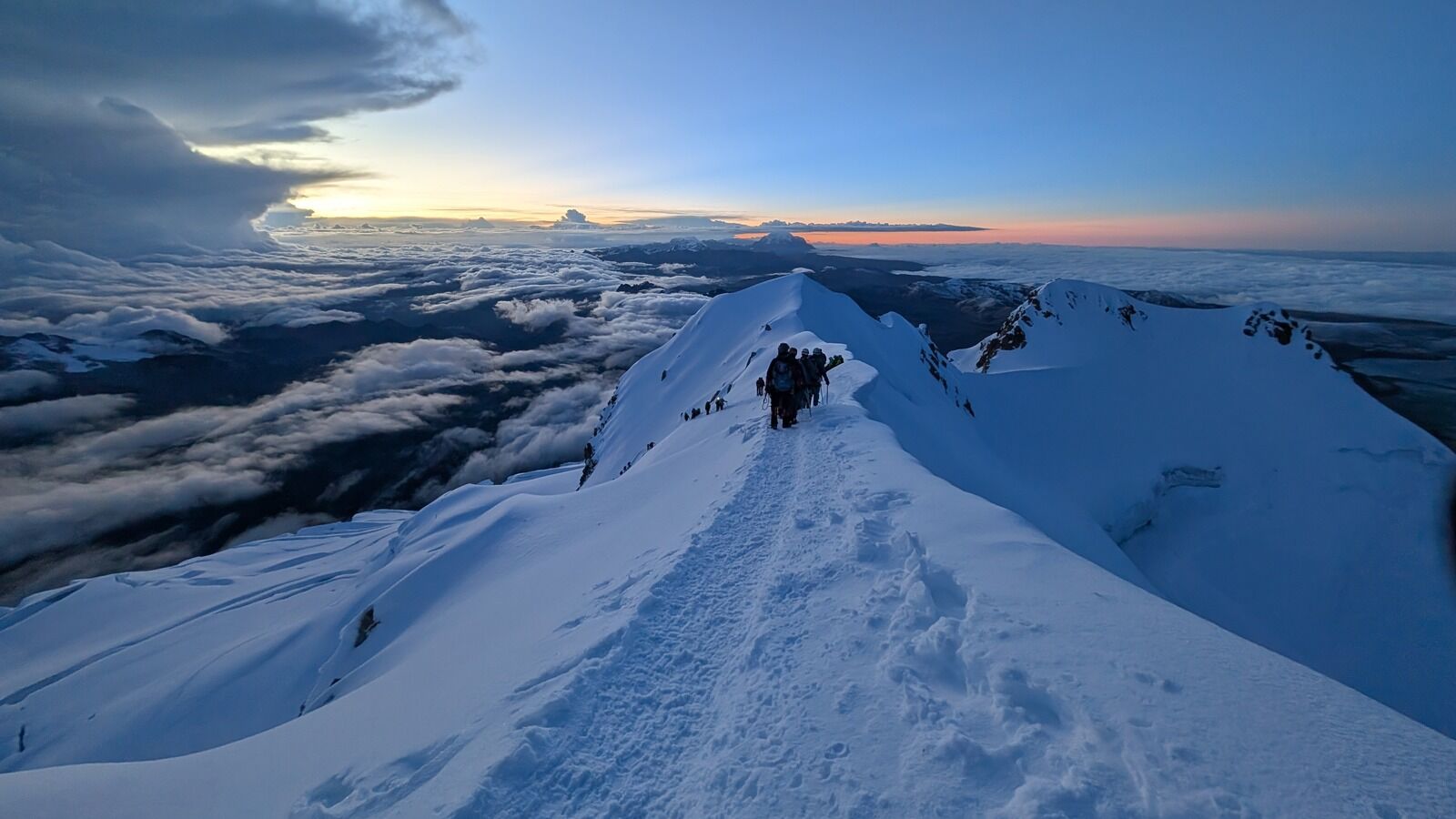
Huayana Potosí
(this week’s cover photo)
The big one. Only a few feet shy of 20k feet (6088m). Our 3 days on the mountain really deserve a piece of their own to fit in all the details, but here’s the (slightly) abbreviated version.
Day one we got all our gear sorted, drove over to the base of the mountain, and spent a few hours on a glacier practicing using crampons and ice axes. We even got to do a bit of ice climbing for fun (not something we needed for the actual climb). It was shocking how out of breath I was after only ice climbing 5m. I’d love to try some more ice climbing at a lower altitude because it was a ton of fun and I think I’d have a bit more stamina not at 15k feet.
This first day was mostly for additional acclimatization and less for making progress up the mountain. We went back to our refugio and spent the rest of the evening getting to know each other. At one point I mentioned something about Pullman and Washington State University, and from the table next to our group I hear “Wazzu? Are you a Coug?”. Turns out one of the guys in the other group grew up just outside of Seattle and went to WSU. We had a fun conversation talking through both the East and West sides of Washington. It’s funny how small the world can feel sometimes.
Day two we had a 2.5 hour hike up to the high refugio, where we would start our summit ascent the next morning. All of day 2 was still on dirt and rock. Looking up towards the monster in front of us, you could see the trail start to climb, and drop out of sight as it worked its way back towards the peak. After an early dinner and an overview of the plan for the morning, we went to bed around 7 so we could try to get at least a few hours of sleep before our wake up call at midnight.
After a few hours of low-quality sleep, we groggily rolled out of bed, ate a meager breakfast of bread and coca tea, gathered our gear, and set out at 1 in the morning to try to summit by sunrise.
The next five hours were spent hiking slower than I ever have in my life. It felt like moving in slow motion. Could I have moved a bit faster on my own? Probably, but I’m not sure by how much. There were several moments where I’d take a series of four or five quick steps on a steep section, and immediately be gasping for three or four breaths to recover.
Just under five hours later all but one of our group members arrived at the summit (the last one was experiencing some altitude sickness and difficulty breathing so returned to high camp). We beat sunrise by about 20 minutes, and got to watch light fill the sky as we took our pictures at the top (unfortunately along with hoards of other people, but such is life. It’s hard to complain too much standing just under 20k feet looking out over the world). The visibility wasn’t perfect, but it was a pretty darn good view for 180°. The other 180° was an ominous looking wall of gray that was slowly moving closer.
After a bit more time at the summit celebrating, we started back down towards high camp. Steps were much easier and we flew down the mountain in 90 minutes. Once we got back to camp, we had a snack and rested for a few hours before finishing our descent out.
An hour after we returned to high camp, I stepped outside to use the bathroom. Remember that ominous gray cloud? Yeah. Visibility was minimal as I shivered, looking through fog and heavy snow. Most of the remaining trail downwards was relatively steep rocky trail. Add on top all of the other people coming down the mountain, and the snow was compacted onto the rocks making for a wildly slick trek down.
On only a few hours of sleep and already tired legs, we eventually braved our way down. This was easily one of my least favorite sections of hiking I’ve ever done. The two and a half slow hours it took us to get up turned into an even slower three hours going down. Thankfully no one hurt themselves, and we escaped to the bottom in communal frustration, exhaustion, and relief.
You never know who you’re going to get with a tour group. Out of all the groups I’ve been on tours with, this group was my favorite. Everyone got along and was excited to get to know each other. Silence was rare. Many laughs were shared. Encouragement abounded. I really lucked out with this one, and it made the trip all the more memorable. This was overall one of my favorite experiences I’ve had in my nearly 6 months of traveling.
It was incredibly difficult to narrow down photos for this one. If you want to see more, you can find them here.


REFLECTIONS
My body was very active this week, and my mind was relatively quiet. No big reflections for this week.
NEXT UP
La Paz has been one of the hardest cities to leave. With more time, I would have loved to stick around and summit some more peaks. There’s so much to do and see around La Paz and I feel like I just scratched the surface with my seven days there.
However, my time is not unlimited (My 30 day Bolivian visa is pushing right up against the 30 day mark). Yesterday I headed to Copacabana which will be my final stop in Bolivia before crossing into Peru. The next few days will be mostly transition and recovery days from the full last week I’ve had before I start picking up the pace again in Arequipa and Cusco.
As always, if you know anyone that you think would be interested in anything I’m writing about, I’d ask that you consider sharing this with them.
Thanks for being here. Talk to you next week.
– Trevor